

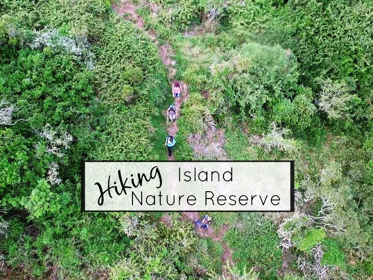
If you were to tell me that it is possible for a family of five from Port Elizabeth to get lost deep in the wild, a mere ten minutes from home, I wouldn’t have believed you. But trust me, it is not that far-fetched. As we discovered on our hiking trip to the Island Nature Reserve.
We have often driven past the signboard to the Island, and wondered what it was. As we have quite a strenuous hiking adventure lurking around the corner in Canada, we were delighted to find out that it offered 16km of pristine wilderness hiking trails. What a perfect location to practice with the kids before our cross global adventure!

Hiking trail through the forest
So we packed our backpacks with rainproof hoodies, lunch, snacks, plenty of water and our camera gear and headed off to conquer the entire reserve. We were given a little map showing the route, but were gutted to be told that trail 4 (which is the one we were looking forward to the most) was closed due to the construction of a tower. The park ranger could see our disappointment, and told us not to worry – we could hike until we encountered the construction sign and then loop back.

The Bushbuck trail is a total of 16km

You can choose which parts of the trail you do
The Island consists of a large and beautiful picnic and braai area for day visitors, and there are a total of 5 hiking trails, which can be done consecutively, or as shorter individual walks. We set out at 11am, aiming to do all 5. In hindsight, I would recommend starting closer to 8am if you want to hike the entire 16km. The first 2 trails wind their way in the Milkwood forest surrounding the picnic area. They are perfect for families with younger kids, to get a taste of hiking in relatively easy and very stunning terrain. Trail 3 leads under the main Seaview Road, and then meanders away from civilisation, joining the stunning and remote trails 4 and 5.

Going under the Seaview Road

Walking as a family with teenagers has its moments. Seldom is everybody happy at the same time. We aim for 4 out of 5, and hit our mark through trail 3. Jacob and Luke strode happily through the forests as they changed from tangled indigenous trees to towering eucalyptus. Cian on the other hand was tired of the trek, and wined along about how we had ruined his Sunday and bemoaned his plight of being stuck on a one way trail leading nowhere – “what’s the point?”.

Recognising the alarmingly antisocial signs of kid hunger, we pushed on nevertheless, aiming to find an open spot where we could stop for lunch and capture some great overhead shots. Pushing it to the point of hangry (angry hunger) overload, we eventually gave up and stopped for lunch in the forest path. I have no photos of that as my hangry boys were no longer playing along (see “How to Get Your Teenage Kids to Pose for Family Travel Photos” for some tips on how to avoid this).
Refreshed, fed and watered, the mood brightened to a happy 5 out of 5, and we were thrilled to discover an awesome concrete beacon, complete with ladder, marking the highest point of the reserve.
![]()
The view from the beacon
From there, it was downhill in more ways than one. Luke took over from where Cian left off, and decided that not only was he sick of spending the whole day this way, but his feet were stinging and aching from the nettles and thorns along the way. (He had ignored our plea to put on his hiking shoes, and slipped past our pre-hike equipment check with his flip flops on).
This did not deter the rest of us from marvelling at the beauty around us. Jacob’s crowning moment was when he stumbled upon a majestic male bushbuck (he always walks at the front to try and glimpse any wildlife before the rest of us scare it away with our chatter and bickering).

It was nearing 2-30pm, and I started getting a bit anxious, as we were still heading away from our starting point. The maths wasn’t adding up. 3½ Hours to get here, and we still had to get back before the 4-30pm curfew. According to my cellphone, we had done 11-12 km so far, and there was still no construction barrier. As we summited a hill, relief flooded in as we saw the closed sign. Following the ranger’s instructions, we turned left, expecting to find the road home.
My heart sank into my new hiking shoes as I saw the T-junction, which didn’t exist on the map or according to the ranger’s initial instructions. Having wandered in loopy paths around the forest, we were completely disoriented and had no clue which way headed back home. Five pairs of achy legs + 2 swollen, itchy bare feet + a clock that ticked steadily towards curfew = a moment of pure panic (x 5).

Using the drone to find our way
We breathed a collective sigh of relief as a few kilometres on, we joined up with the well-marked trail again and pushed on back to the car.

Delighted smiles all round – including from the park rangers who could now lock up and go home without having had any disasters on their watch.
All-in-all, a fabulous family adventure!
Click here to watch on YouTube if it does not display correctly on your device
The Island Nature Reserve is located around 25km from Port Elizabeth on the Seaview Road. It consists of 480Ha of indigenous coastal forest and 16 km of hiking trails, which can be done in smaller sections or as one long hike.
The reserve is open from 8am-4-30pm, and a small entrance fee is charged (we paid R20 per adult and R10 per child under 12).
Learn more about The Island Nature Reserve on Nelson Mandela Bay Tourism’s site – http://www.nmbt.co.za/listing/island_nature_reserve.html


I got to do The Island about a year or so ago. Such a beautiful place so close to home. I did find they really need a proper map and perhaps a bit more signage.
I think they may have improved the signage since then, as it was really good. The reason we had a problem was that we veered off the track due to it being closed for construction. They were not too sure when the construction will be finished, but when it is, we’ll probably go back and just do trails 4 & 5.


2 Comments