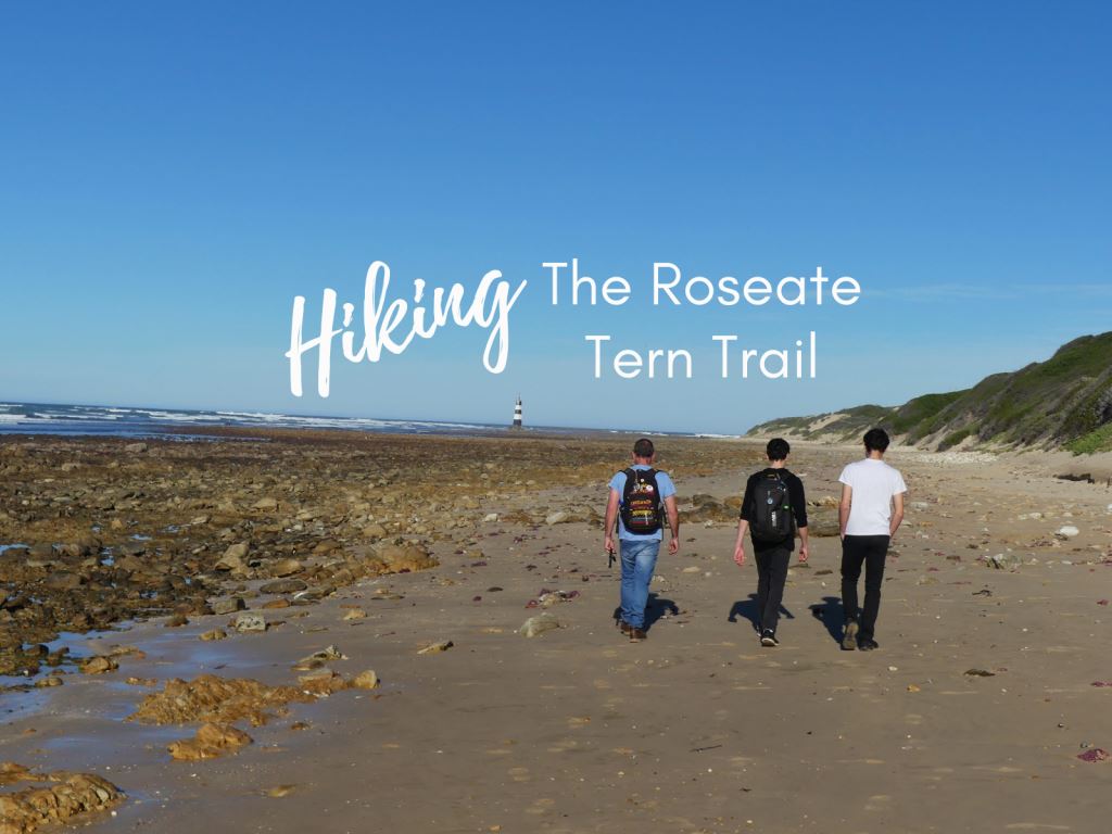
We have often visited Cape Recife Nature Reserve to see the lighthouse and beach, but had never done it’s Roseate Tern hiking trail until recently. The 9km trail leads along a spectacularly wild beach and winds its way past an ancient beacon and lighthouse, through some impressive World War II ruins to an amazing viewpoint, across wetlands singing with birds, past a couple of dams with a peaceful bird hide in a circular route that ends where it starts.
We thoroughly enjoyed the entire hike, particularly the ruined army barracks and military observation post and highly recommend it as an ideal day outing for families and one of the top things to do in Port Elizabeth.
Here is a photo tour of the lovely hiking trail:
The parking is just before the entrance boom, next to Pine Lodge. The trail starts opposite Sanccob, where you can ask for a printed map and directions and follow the penguin tracks to the beach
You can also download a PDF map and directions on NMBT’s website
From Sanccob, its a short walk to the beachAnd what a spectacular beach it is!We chose to stay on the beach rather than follow the map which veered off inland and then onto the beach againThere was quite a lot of plastic washed up on the beach and we collected a few bags full as we walkedUntil we saw this sign! Oops.The beach is full of rocks and interesting remains of sea lifeWe reached the beacon and admired the birds sitting on and around itNext stop, the lighthouseWe went in the afternoon and the low winter sun cast dramatic long shadows across the beach. This lighthouse is a photographers dream!Ralph played with his Insta360 with Cian who is the only one of our boys who is more than happy to model for usFather & Son (& Lighthouse)The beach after the lighthouse is packed full of gorgeous little shells.And rocks perfect for boulderingKing of the Castle!We were feeling a bit lost, there having been no signposts along the way. Then we spotted this rusty sign and knew we were on the right track. The only other sign we saw was about 50m further along the beach – identical to this but with the arrow pointing in the opposite direction (amusingly confusing).We seemed to have walked for ages, and were getting worried that we had missed a turn.Eventually we came upon this sign, pointing in the wrong direction but there was a path leading inland so we followed itFirst, a shallow staircase up the dunesSpot Luke – the little white dot on the horizon. He likes to walk ahead (I suspect it may have something to do with avoiding being in the photos)At least Cian is a keen poser, and so agile!We arrived at the ruins. What an amazing place!There is something mystical about a place that oozes history. It was easy to imagine the barracks full of World War II soldiers, protecting the sleepy coastline.There are quite a few blocks to walk through and around, lots of little bedroomsin a row and the general’s house at the end.From the barracks, you can see up to the military observation station aboveIt is surprisingly large – it looks small from far away but it is 3 stories tall!With an amazing view in every direction. Here we overlooked the army barracks and the beach we had just walkedThe other direction faces the path to come – the dam with the bird hide and views right across Algoa Bay behindFrom the observation post, the trail meanders over some shallow dunesAnd through wetlands full of singing birdsThe final part of the trail is through some damsThere is a lovely bird hide overlooking the largest dam (and we caught up to Luke and even managed a photo!)The hide is really peaceful and contains a list of resident birdsFrom the bird hide, it was a bit confusing which path to take back – we turned right and chose this one, surrounded by tall elephant grass, which emerged back on the road near Sanccob. I suspect we should have turned left instead, but we found our way back anyway.
Trail Facts
Cape Recife Nature Reserve is accessed via Marine Drive, at the same turnoff as Pine Lodge. It is open daily from 7am until 9pm.
Trail length – 8-9km, approximately 3 hours.
Difficulty – easy
Terrain – Relatively flat with a couple of small inclines. The first half is along the beach and the second half through fynbos and grassy terrain.
Cost – No charge if you park outside the security boom. If you prefer to park inside the reserve, you need to buy an entrance permit (approx R75 per vehicle) at Pine Lodge.
TIP: Walk in a group and finish the trail by 5pm, when the security guard at the gate ends his shift.
We're an ordinary family living an extraordinary life as we discover the magic in our home country of South Africa and explore the world together. We aim to inspire you with our stories, empower you with travel tips and make you fall in love with our beautiful rainbow nation.


Leave a Reply